
On Friday as the United Nations Intergovernmental Panel on Climate Change released its most recent update on climate change, I was meeting with congressional, federal, and other state officials about coordinating for a changing world.
During the meeting, the head of my state’s planning office passed around a few sample inundation maps. One of them was of Jamestown, which is made up of two islands in Narragansett Bay connected by a natural and fragile causeway.
Over the past few years I’ve seen lots of these maps. I will see many more as my office works with other agencies to determine the vulnerability to wastewater infrastructure from rising seas, increased levels of storm surge, and more intense precipitation. But this particular inundation map broke my heart. It showed the areas of Jamestown subject to rising seas and it included a solid swatch of red on the causeway that connects Jamestown’s two main islands. While the town’s largest area is accessible to the mainland by a large bridge (which isn’t going anywhere anytime soon), the town’s western “tail” is only accessible via that small sandy causeway.
What hurt was that the map’s red swatch indicated areas threatened with submersion during increasing storm surges and, eventually, permanently because of a rise in sea level.
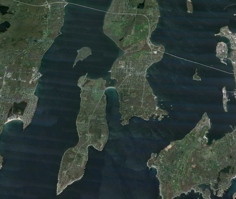
Beavertail State Park is on that small island to the west. This funny sounding place is one of the planet’s most beautiful and invigorating. It certainly delights my mom, even if in her old age she can't explore its shore as she well as she did with my dad. But I still drive her there—over the causeway—so that she can stare out into the ocean and let the salty wind rush around her.
Beavertail's rocky tip cuts into Narragansett Bay like a ship’s bow aimed into the Atlantic. A nineteenth-century lighthouse sits close to the island's edge, often flashing and sounding warnings to passing sailors. These are necessary because the glacial shore rolls steadily into offshore reefs. But those dangers are assets for people onshore. A mix of smooth and layered rock provides hundreds of viewing and fishing platforms and many more crevices and tidal pools for children of all ages to explore. All this is accompanied by the ongoing trio of gull cries, wave upon wave on rock, and the wind from far-off waters.
 |
The causeway during Tropical Storm Sandy.
Photo Andy Manca
|
I can’t imagine how anyone at Beavertail could be an atheist.
But as the Atlantic Ocean rises and my state’s coastal features move, erode, or disappear, Beavertail’s causeway will likely vanish, as that projection map demonstrated (and as experiences have already shown in major storm events). In time, the projections say, the only visitors to this spot will be boaters who may have to hike long distances to experience what so many generations of Rhode Islanders and so many more visitors have loved so much for so long.
Given all the news on the IPCC report, the probable isolation of Beavertail is hardly the worst issue to speak of. As I plan for the worst at work and home, there are many more pressing scenarios than a causeway that takes automobiles to Beavertail, even if the island is home to a number of private property owners. Elsewhere, entire communities are seriously threatened along Rhode Island’s 400-mile shoreline (which is a sizable number considering the state is only some 1,200 square miles) and along the East Coast.
 While
someone like me can become numb to these projections—even to the scenes of
destruction from events like Hurricane Sandy—there are times when the truth
sinks in, when climate change gets personal. For instance, in 2010 my
hometown’s river made national news when it flooded the village a few blocks from
me. In the midst of the turmoil I couldn’t help but think of the growing amount
of meteorological tending data that predicted such events.
While
someone like me can become numb to these projections—even to the scenes of
destruction from events like Hurricane Sandy—there are times when the truth
sinks in, when climate change gets personal. For instance, in 2010 my
hometown’s river made national news when it flooded the village a few blocks from
me. In the midst of the turmoil I couldn’t help but think of the growing amount
of meteorological tending data that predicted such events. In a similar way, the truth also cuts deep when I look at projections.
Because I grew up in Rhode Island, I know many of its threatened coastal features and small villages from my childhood, when my mom and dad, brothers, and cousins would spend days at the shore. My dad died seventeen years ago but I can still see him deftly skipping stones as he patiently taught me that rock-throwing skill on the sunny waters off Jamestown. (You really do have to throw a well-shaped, flat stone at just the proper angle. And there really is a right method of holding the stone when throwing it.) I remember managing a double or triple skip, but most times my stones would hit the water hard and sink. Either way, my dad kept showing me what I needed to know, even if I wasn't always the best student.
The particular section of shoreline where this all took place in the early 1970s is just around the bend from Beavertail. In time it will be underwater even during low tides. Later it will be part of the bay’s floor as seas rise and many coastal gems become memories.
 |
| Photo: Flicker/by sapienssolutions
|
These losses will hurt and hurt all the more when we lose what we love not because nature is taking its course but because we were too slow and too stubborn to see what we were doing—because we couldn't see what was happening and change the way we lived.
Let us hope and pray that events unfold otherwise—that those maps may be wrong—if it is not already too late to do so.
No comments:
Post a Comment
Thanks for commenting. No input or question is too small. You're encouraged to be passionate, feisty, and humorous. But do so with civility, please.